The Whitechuck Glacier supplies flow to the headwaters of the Whitechuck River. Its white expanse has graced these headwaters for thousands of years. The Whitechuck Glacier retreated slowly from its advanced Little Ice Age position until 1930, while rapidly thinning. Thus, prepared it began a rapid retreat in 1930. This rapid retreat culminated in the total disappearance of the north branch of the glacier in 2001. No more does this glacier dominate the headwaters, and its demise has and will continue to alter the hydrology of the Whitechuck River headwaters. How did this glacier die and what are the impacts when a glacier disappears?
A progressive temperature rise from the 1880’s to the 1940’s led to ubiquitous retreat of North Cascade glaciers. The Whitechuck Glacier was no exception: by 1950 the glacier’s northern terminus had retreated 1050 m and the southern terminus 750 m. More importantly the glacier had thinned dramatically. The glacier had flowed down relatively gentle slopes into a large flat basin. Between the two termini a lateral moraine is plastered along the rim of the basin at 2015 m, like the high water mark on a bathtub. Immediately beyond the current terminus, Point 2065 m was overridden by ice indicating the glacier had thinned by more than 60 m in the lower part of the Whitechuck Basin.
![]()
North Branch of the Whitechuck GLacier in 1973 (Neil Hinckley and 2006 (Leor Pantilat)
The USGS topographic maps of Glacier Peak from 1958 show the still large Whitechuck Glacier with an area of 3.1 km2 (Post et al., 1971). The Whitechuck Glacier on this map still has two branches with two termini, the northern branch feeding the northern terminus, and the southern branch feeding both the northern and southern terminus. Both branches exceeded a mile in length in the 1950’s (Figure 2 and 3).
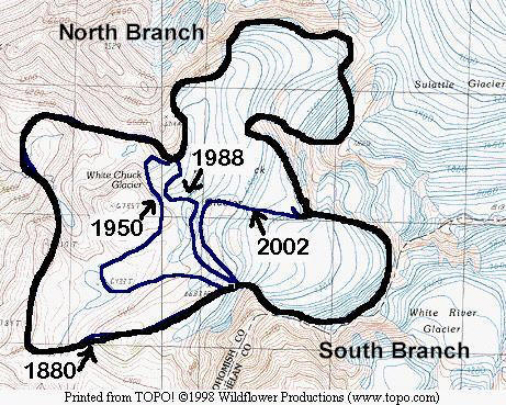
Figure 1: Map of the Whitechuck Glacier with the USGS 1988 Base Map that is based on 1984 aerial photography. The terminus locations for 1880, 1950, 1988 and 2002 are indicated.
The USGS remapped the area based on aerial photographs from 1983 for the 1984 USGS maps of the East Glacier Peak and West Glacier Peak quadrangle. These indicate the southern terminus had retreated 450 m, from the 1958 map terminus position. The northern terminus had retreated 180 m and was still near the lip of a basin at 1975 m.
Field examination of this glacier in 1988, 1995 and 2002 by the North Cascade Glacier Climate Project, along with comparison of aerial photographs from Austin Post of the USGS from 1961,1964,1965,1967, 1970,1972, 1975 and 1979, were used to map the more recent changes in both glacier thickness and extent.
In 1988 the southern terminus of the glacier ended in a new lake at 2020 m (Figure 4). The lake is not in evidence on the 1984 updated USGS topographic maps or in 1979 aerial photographs of the area. The terminus had retreated 510 m since 1955, and 140 m since 1967. The lake that had been the terminus location in the 1958 map still exists, but is now 375 m from the edge of the new terminal lake. The south branch of the glacier is thin and stagnant in the lower 200 m. Above this point crevasses are in evidence and the convex profile indicates that the south branch was still an active glacier in 1988. This remains the case in 2005, while in the former location of the north Branch several small lakes are evident where the glacier used to be.
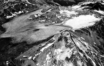
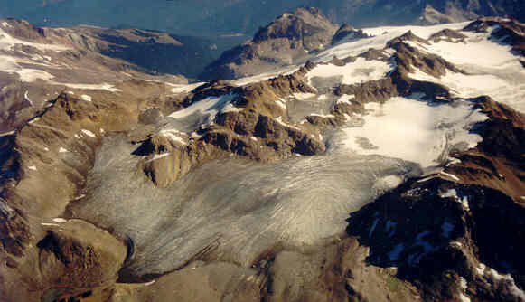 Figure 4: Whitechuck Glacier in 1988 at right the north branch on the left side of the glacier has become disconnected at the top, and has no residual snowpack. The south branch in the center still has a small accumulation area. A small lake is starting to from at the terminus of the south branch. The glacier in 2005 at right no longer has a north branch and three new lakes are evident.
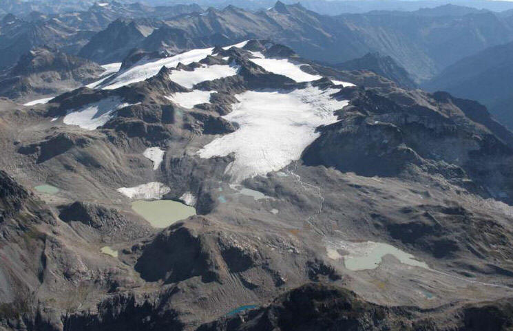
The northern terminus of the Whitechuck Glacier ends in a lake basin at 1980 m. This basin was filled with glacier ice in 1967. In 1988, the new lake was 210 m long and still expanding. Total retreat of the terminus from 1955-1988 was 410 m. The northern half of Whitechuck Glacier extending up to Glacier Gap was a rapidly melting, concave, stagnant ice mass in 1988. The north branch had no crevassing and even the ice at the glacier surface lacks the normal blue ice color of glacier ice. Instead it was a dull dark grey color. The distance from the terminus to the top of this section of glacier is 1550 m. Total glacier area has decreased from 3.1 km2 in 1958 to 1.8 km2 in 1988 (Figure 6).
By 1995 the southern terminus had retreated an additional 50 m expanding the lake at the terminus (Figure 7 and 9). The south branch of the glacier no longer actively feeds the northern terminus, as the ice had become to thin for motion. The glacier ended in the lake on a gentle slope. The northern lobe was stagnant ice with no retained snowcover, and was only a half-mile long, we quickly ascended this section on crampons in 1995. The upper most section had separated from the main body of the glacier at 2134 m. The area of the glacier had declined to 1.6 km2 in 1995.
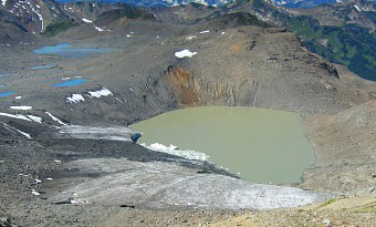
In 2002, the northern branch of the glacier was entirely gone (Figure 10). Instead of an ice filled valley extending 1.6 km from the lake to Glacier Gap at the former head of the glacier, there was a boulder-filled basin. There is a new lake that has developed at 2000 m, 400 m northeast of the terminus lake. The walk to Glacier Gap took much longer picking our way through the loose bouldery-terrain.
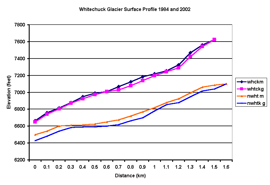
The southern lobe of the glacier was still thinning slowly, and retreating, (Figure 8). A comparison of glacier surface elevation in 1983 and 2002 identifies the average thinning in the twenty year period from the USGS aerial photography in 1983 to 2002, for the northern branch is 15 m . For the southern branch the average thinning is 6 m. The total area of glacier ice left including the stagnant section by the northern terminus is 0.9 km2 less than 30% of the area of just 30 years ago. At the current rate of thinning and given the current ice thickness of 35 m this glacier will endure for the first half of this century. The south branch is not close to equilibrium and though its retreat is hastened by the recent warm weather, it still has not completed its adjustment to the post Little Ice Age conditions. In the case of this glacier, its response time to approach a new equilibrium is in excess of 100 years (Pelto and Hedlund, 2001).
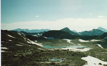
Figure 7: Looking from the terminus of the south branch of the glacier in 1995. The terminal moraine is visible as the ridgeline. In 1950, the glacier terminated at the lake (now center of photo).
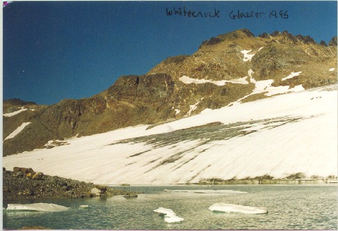 Figure 8: The south branch terminus in 1995.
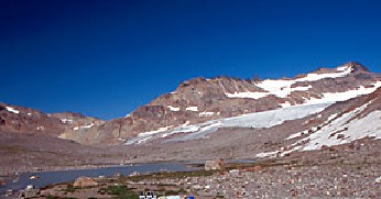 Figure 9: The south branch terminus in 2002.
The retreat of this one glacier has led to the development of six new lakes, three in the last twenty years. The two smallest of these may fill in with sediment. The 3.4 km2 of new bare bouldery surface can be slowly colonized by vegetation. Compared to many areas of glacial retreat where natural revegetation takes place fairly rapidly, there it is an achingly slow process, where even the portions of the basin exposed for fifty years have gained little colonizing vegetation. This may be because of the extremely limited growing season (the basin still has snowcover into July), and its relative isolation from seed sources. The Whitechuck Glacier has simply not been happy with the 1.4o F warming the North Cascade region has experienced since the 19th century, and its reduced income in the form of reduced accumulation, and increased expenditures in the form of increased ablation have led to a negative balance in its glacier ice savings account.
Glacier biota, such as ice worms, springtails, algae, bacteria, and other invertebrates and microbial organisms living on, in, and under these glaciers, will have experienced a substantial change in population. This represents a substantial loss in biological processing and material that would otherwise be transferred downstream. The amount of runoff entering the Whitechuck River will decline substantially in the summer. For thousands of years each square meters of glacier has contributed 800 gallons of runoff from July I-October 1. With the loss of glacier ice, this contribution should drop by 65-80% based on observations at two other sites where glaciers have disappeared (Pelto, 1993; Pelto, 1996). The change from 1950-2002 in glacier area has reduced summer glacier runoff by 1.5 billion gallons annually. This represents a loss of between 20 and 25 cfs for the Whitechuck River. The water will also be less sediment laden and warmer. The impact will be less water for the fall salmon runs, and less food in amount and processing for stream invertebrates on which salmon feed downstream in the Sauk and Skagit Rivers.
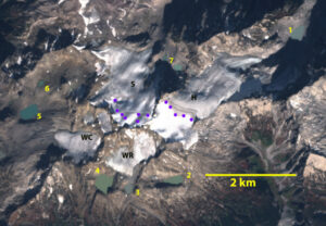
October 19, 2022 Sentinel image of Whitechuck (WC) and other nearby glaciers. Indicating lack of snowcover and ongoing recession.
The glacier has in the last decade frequently lost nearly all of its snowcover, which is indicative of a dying glacier, note 2014, 2019, 2021, and 2022. By 2022 several years the glacier had further declined in area from 09.km2 to 0.5 km2 This was also a year with a late ending ablation season and the October 19th image indicates a glacier that is essentially bare of retained snowpack.
This story is not isolated to this drainage. NCGCP has watched the disappearance of several glaciers in the North Cascades Milk Lake Glacier, Lewis Glacier, Hinman Glacier, and Snow Creek Glacier (Pelto and Hedlund, 2001). All 47 glaciers monitored are retreating. The same story is unfolding in Glacier National Park, Bolivian Andes, Pyrenees, and Ruwenzori Mountains to name a few.
 References
Burbank, D.W. 1981. A chronology of late Holocene glacier fluctuations on Mt. Rainier. Arctic and Alpine Res., 13, 369-386.
Ebbesmeyer, C.C., D.R. Cayan, D.R. McLain, F.H. Nichols, D.H. Peterson, and K.T. Redmond. 1991. 1976 step in the Pacific Climate: Forty environmental changes between 1968-1975 and 1976-1984. In Betancourt, J.L. and Tharp, V.L., Proc. On the 7th Annual Pacific Climate Workshop, 129-141.
Hubley, R.C. 1956. Glaciers of Washington’s Cascades and Olympic Mountains: Their present activity and iTs relation to local climatic trends. J. Glaciol., 2(19), 669-674.
Krimmel, R.M. 1994. “Water, ice and meteorological measurements at South Cascade Glacier, WA 1993 balance year. USGS OFR-94-4139.
Krimmel, R.M. 1996. “Water, ice and meteorological measurements at South Cascade Glacier, WA 1995 balance year. USGS OFR-96-4174.
Krimmel, R.M. 1999. Mass balance and volume of South Cascade Glacier, Washington. Geografiska Annaler, 81A, 653-658.
Long, W.A. 1955. What’s happening to our glaciers. The Scientific Monthly, 81, 57-64.
Miller, C.D. 1971. Chronology of neoglacial moraines in the Dome Peak Area, North Cascade Range,
Washington. Arctic and Alpine Research 1, 49-66.
Pelto, M.S. 1993. Current Behavior of Glaciers in the North Cascades and Effect on Regional Water Supplies. Washington Geology, 21(2), 3-10.
- North Cascades Glacier Retreat, Wild Cascades,Spring 1995, 17-22.
1996, Changes in Glacier and Alpine Runoff in the North Cascade Range, Washington USA 1985-1993.
Hydrological Processes, 10, 1173-1180.
- Changes in glaciers onGlacier Peak in the last 100 years. Mazamas 1997, 29 and 39.
- The impact of global warming on glacier mass balance in the North Cascades, Washington and JuneauIcefield,Alaska. World Resources Review. 13, 91-105.
2001: with Jon Riedel. The spatial and temporal variation of mass balance on North Cascade glaciers., Hydrological Processes, 15, 3461-3472
2001: with Cliff Hedlund: The terminus behavior and response time of North Cascade glaciers. Journal of Glaciology 47, 497-506
Porter, S.C. 1986. Pattern and forcing of Northern Hemisphere glacier variations during the last millenimum. Quaternary Res., 26, 27-48.
Post, A., D. Richardson, W.V. Tangborn, and F.L. Rosselot. 1971. Inventory of glaciers in the North Cascades,Washington. USGS Prof. Paper, 705-A
Rusk, C.E. 1924. Tales of a Western Mountaineer. Houghton Mifflin Co., New York.